
09.04.2024
Deploying Cutting-Edge Technologies for Immediate Response to Kazakhstan's Flooding Emergency
Early April 2024, abrupt and premature warm weather conditions triggered extensive flooding in Kazakhstan, resulting in a massive snowmelt that inundated numerous rivers across the country. Ten regions declared states of emergency following severe floods in the northwest. President Kasym-Zhomart Tokayev described it as the worst flooding in 80 years, prompting the evacuation of over 75,000 people and the deployment of the national army for rescue and aid operations.
In response to the disaster, the International Science and Technology Center (ISTC/Team PPRD Med) is supporting the Government of Kazakhstan by providing satellite imagery and space analytics. Collaborative efforts involving the Ionosphere Institute in Kazakhstan, ISTC, and its highly specialized PPRD Med team for the Center for Emergency Situations and Disaster Risk Reduction (CESDRR) in Almaty, with the full support of the Delegation of the European Union to Kazakhstan, aiming to enhance situational awareness and implement risk mitigation measures.
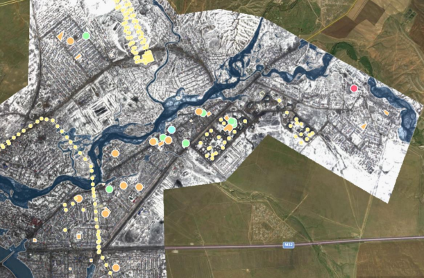
The initial analysis of the Kazakhstan floods under ISTC from March 31 to April 4, 2024, conducted by Dr. Philippe Geffroy, Dr. Jean Muylaert, and their partners (GSI and University of Twente), utilized Planet Scope and Sentinel-2 satellite data for comprehensive space-based assessment of flooding evolution, critical infrastructure impact, and preparedness measures. Significant evacuations and property damage caused by warming temperatures and heavy rains were identified as well as its potential impact on Aktobe's critical infrastructure (energy power supply, schools, pumping stations, dams, etc…).
The study employed pre- and post-event imagery to delineate flood extents, revealing the inundation of some buildings and the overall resilience of major infrastructure. Analysis of the Aktobe dam indicated heightened river discharge with minimal structural damage. Flood simulations AI-powered algorithms proved effective in forecasting floods, aiding in preparedness, mitigation, and, ultimately, prevention strategies.
Satellites images and analytics underscored the extensive flooding resulting from snowmelt in the mountainous Oural region, which affected lower-lying floodplains and smaller towns like Yrgyz and Kobda in the Aktobe region. Some buildings were affected, and the severity varied across different areas.
In conclusion, the study provided crucial insights and actionable analytics into the scale and repercussions of the Kazakhstan floods, underscoring the significance of satellite-based monitoring for effective disaster response and mitigation efforts.
Currently, ISTC and its partners, working under the PPRD Med project www.pprdmed.eu across 10 southern and eastern Mediterranean countries, are on the way to digitalizing National Risk Assessment by adopting space analytics, artificial intelligence, fast flood simulation tools, early warning wildfire simulation and monitoring tools, and advanced digital technologies. These resources provide immediate situational awareness, directly supporting Kazakhstan's emergency response centers.